The landscape of Shatt el-Rigal in
the northern part of Gebel el-Silsila, where many hundreds of Middle Kingdom
rock inscriptions have been discovered.
Gebel el-Silsila was an important
quarrying site from earliest times, offering a plentiful supply of good quality
sandstone for pharaoh’s building projects, as well as being a vital strategic
trading point on the boundary between Egypt and Nubia.
A Continuation of Rock Art
As we highlighted in our previous
article (AE113), since earliest times, people coming to Gebel el-Silsila have
left their marks on the rock faces. Moving from prehistory to early history, it
is evident that early dynastic rock art is less common than during previous
periods. With the development of the hieroglyphic and hieratic scripts, there
is instead a clear change from pictographic images to textual rock
inscriptions, which normally consist of names and titles. When rock art is found,
the early dynastic repertoire reproduces many of the previous motifs, including
hunting scenes (men, dogs, and captured animals), designs from the natural
fauna, boats, and so on. New for Gebel el-Silsila in this period is the
appearance of footprints or sandals, and anthropomorphic figures are portrayed
not only as hunters, but are also shown in praising positions, and soon
thereafter as deities.
By the beginning of the Middle
Kingdom (c. 2055 BC), figural rock art had developed into complex scenes, exemplified
in a panel in the southern-most part of the West Bank. The scene depicts a
human figure with raised arms, a dog, and several horned animals – a
traditional hunting scene – but with the addition of several birds identified
by John Wyatt as ostriches, and a crowning circle, most likely representing the
sun. Thus, sun worship has arrived at Gebel el-Silsila.

.jpg "The cartouche of Pepy I of the Sixth Dynasty (top), with a drawing for clarity (below). This is the earliest hieroglyphic inscription found at Gebel el-Silsila, found on the West Bank at Rock Inscription Site 8.")
When Gebel el-Silsila Became Kheny
The ancient Egyptian name of Gebel
el-Silsila was Kheny or Khenu ![]()
which is generally translated as the “Rowing
Place”, but could equally signify the “Mouth of the River”. Its earliest
attestation is a reference from a Fourth Dynasty mastaba at Dahshur belonging
to prince Iynefer, son of Sneferu. Shortly thereafter the earliest hieroglyphic
inscription at Gebel el- Silsila itself appears: a cartouche of Pepy I, located
along the main cenotaph pathway on the West Bank (Rock Inscription Site
GeSW.RIS.8). Surrounding this royal name is a vast number of Middle Kingdom
signatures as well as a couple of Predynastic giraffes, and graffiti from later
visitors to the site. No other Old Kingdom texts have been confirmed thus far.
It is plausible that the site had already become a state-controlled quarry by
this time, considering Pepy’s other quarry expeditions to Nubia. However, the
strategic location of Gebel el-Silsila, with a clear line of sight in all
directions, may also have inspired the army to set up a camp there and use the
site as a for- ward base for military campaigns into Nubia.

The name Kheny occurs again in a Middle Kingdom papyrus, acquired in Thebes at the end of the nineteenth century by Charles Edwin Wilbour. This text later came into the possession of the Brooklyn Museum, and was labelled as Papyrus Brooklyn 35.1446. Written in black ink hieratic, line 21 gives the name of a fugitive of the state called “Hemenusra, son of Khnumhotep” and describes him as a “man of Rokhen(y) of the department of the plough-lands of …”. The topographic name is generally accepted as denoting “Kheny”, marking the border with Nubia, at Egypt’s south- ern-most point.
Another text, Papyrus Berlin 10495, provides us with the topographic name of Kheny in a list of seventeen Middle Kingdom fortresses. Here the site is again considered the boundary between Egypt and Nubia, but now marking the northern-most fortress in Nubia. The two references to Gebel el-Silsila as a boundary between Egypt and Nubia are supported on site as well, epigraphically, geologically and archaeologically. As we will see below, Rock Inscription Sites 11-12 are situated at the edge of the mountainscape on the plateau, and overlook the entire plain to the south, which today is agricultural land stretching all the way down to the Roman Ras Ras Temple (just south of Gebel el-Silsila, north of Kom Ombo).

Thus, the Rock Inscription Sites mark a natural
boundary in the south, which is perhaps why they were marked with several
cartouches of Senusret I, the Twelfth Dynasty king who first extended Egypt’s
southern border. The natural boundary is also marked in the geological
formation of the gorge which, when the Nile’s waters receded after the
inundation, became like a cataract which people and animals could safely cross.
Epigraphically, the team has located a Middle Kingdom inscription giving the
name of an “overseer of the fortress”, which supports the information given in
Papyrus Berlin 10495. Additionally, the team has recently identified a
structure that may have functioned as a fortress, which will be excavated next
season.
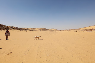
.jpg "Surveying the Middle Kingdom road")
Middle Kingdom Activity
There are several focal points for
the ongoing epigraphic and archaeological documentation of Middle Kingdom sig-
natures and activity in the region. The area under investigation begins at the
famous Wadi Shatt el-Rigal in the north and meanders along the Nile and the plateau
to the far south of Gebel el- Silsila (West Bank) where the mountain meets the
agricultural belt. Sections of a wide paved road survive throughout this area,
and several inscriptions have been documented on the horizontal rock surface,
next to the piles of stone created during the preparation work for the building
of the road (clearing of the road surface).

Since Petrie’s studies at the site,
several scholars have documented Middle Kingdom presence in the north,
naturally focusing on the cliff-faces adjacent with the monumental scene of
Mentuhotep II. However, despite the efforts of Caminos and his students in the
1980s, barely any of the texts strewn across the landscape of Gebel el-Silsila
have been published. To rectify this, our team began a larger archaeological
study in 2013, which led to the discovery of hundreds of signatures and shorter
texts that occasionally provide us with information regarding the geographic
origin and profession of individuals and their activity in the region. From
this, we have been able to create a directory of several individuals active on
site during the Eleventh and Twelfth Dynasties. Two areas of Middle Kingdom
activity will be summarised here: ‘Pottery Hill’ (= Rock Inscription Site 9)
and ‘Senusret’s Rocks’ (= Rock Inscription Sites 11-12).
Pottery Hill – GeSW.RIS.9

Several inscriptions are situated
in an area known to the team as Pottery Hill, which is a small mound containing
a cluster of twenty-eight stone huts that were used by the quarry workers for
storage. It is located on the plateau above a quarry harbour on the west bank.
The nickname Pottery Hill derives from the fact that the mound is littered with
pottery: thousands and thousands of sherds that bear witness to a once very
active site. The team’s archaeo-ceramicist Dr. Sarah K. Doherty carried out an
analysis of this pottery and discovered the majority was used for the storage
of food and liquids. As with all archaeological sites, material visible on the
surface belongs to the last phase of activity; at Pottery Hill the pottery
primarily dates to the Roman Period. However, immediately below and to the
north of the texts – and they run from north to south, reading from the right.
The team recently published a selection of these texts, providing us with the names
and professions of several visitors:


“Seal-bearer (or treasurer) of the
God, Ihawka”
“Expedition leader, Sobek-hotep”
“Overseer of the southern quarry,
Thenn”
“Overseer of the southern quarry,
Khonsu-hotep”
“Overseer of the southern quarry,
Ankhemara”
“… of the southern quarry, director
of the crew, Ptah-Seshem”
“Quarry inspector Meru”.
Several of the names already occur
during the Old Kingdom, but other names, such as Meru, are certainly names only
found from the Middle Kingdom, for which a Middle Kingdom date has been
proposed. The team believes these texts belong to a group of high-ranking
officials involved in the quarry expeditions. In addition to the texts, there
are depictions of two boats, one of which is similar to a vessel occasionally
used as a determinative for the place-name of Kheny. The
presence of two boats may emphasise the nature of the expedition or specify the
professions of the men listed. For example, the title is a frequent nautical
title, used by the crew leader, which presumably from Gebel el-Silsila by ship.
Moreover, the word translated here as ‘quarry’ may incorporate a reference to
the nautical element of quarry work, that is a hill, the paved road and its
series of inscriptions indicate there was already activity at Pottery Hill
during the Middle Kingdom.
.JPG "One of the two rock carvings of a boat found at Pottery Hill. The style of boat is similar to the hieroglyphic determinative for the place name ‘Kheny’")
The texts are arranged neatly together
on a smooth, horizontal rock surface, in an area cleared from pebbles and sand,
adjacent to a large stone pile. They are positioned so as to be read from the
road and Pottery Hill – that is for a person standing to the east of the
quarried harbour or a quay associated with the quarries. Such a harbour is
located immediately below Pottery Hill. There is also a standing figure of the
local hippopotamus-goddess Tausret (although severely eroded) as well as a
footprint/sandal print with a Middle Kingdom signature. The text inside the
footprint is poorly preserved and very faded, but the style of the owl-sign is
identical to those of adjacent Middle Kingdom texts, confirming its Middle
Kingdom date. While feet and sandal graffiti occur frequently during later
dynastic periods, the Gebel el- Silsila graffito is unique in confirming the
existence of footprint carvings as early as the Middle Kingdom.

.JPG)
Senusret’s Rock – GeSW.RIS.11-12
The Rock Inscription Site known to the team as Senusret’s Rock is located in the far south of Gebel el-Silsila, at the edge of the plateau overlooking the agricultural plain. The boulder- like outcrop that makes up the RIS displays a total of forty-two pictorial and textual engravings, ranging from Predynastic petroglyphs to Roman game boards. A vast number, though, are Middle Kingdom texts providing us, again, with the names and (sometimes) professions of the people once active on site. Among the more important texts are three repetitions of the birth and throne names of Senusret I, two of which are oriented towards the east, and the third southwards. The best example is a horizontal cartouche situated on a vertical, south-facing cliff-face of locale GeSW.RIS.12.
.jpg)
.jpg)
“Year 45 (of the reign) of King of Upper and Lower Egypt, Kheper-ka-Ra, Son of Ra, Senusret”

Current Thoughts on Gebel el-Silsila during the Middle Kingdom
Over the millennia, the Nile forced
its way into the sandstone massif to create a deep and narrow gorge, providing
the ancient Egyptians of the Middle Kingdom with a strategic location from
which to oversee, and protect Egypt from, its southern neighbours. The
formation of this nature-given barrier likely gave rise to the site’s ancient
name, Kheny, the ‘Mouth of the River’. Presumably, the site was also a
lucrative quarrying location. The combination of natural barricades in all
directions, and a supply of valuable golden sandstone made Gebel el-Silsila the
ideal site for a fortified military encampment to protect the quarries and
facilitate trade.

As mentioned above, the team has
now found epigraphic evidence of a fortress in an unpublished Middle Kingdom
inscription by the ‘overseer of the fort’. This title confirms the inventory of
Middle Kingdom fortresses listed in Papyrus Berlin 10495. However, with no
excavation or documentary evidence for such a fortress – Sir A.H. Gardiner
himself declared “no fortress is known at Silsilis” – there has been no attempt
to understand the site’s position within the larger landscape until now.
Line of Sight
There is one method that is applied
to all investigations of landscape archaeology at Gebel el-Silsila (and
elsewhere): the ancient use of ‘line of sight’ as a means of connecting various
structures. At Gebel el-Silsila the team used this method early on to record
the relative locations of a string of coexistent Roman stations, outlook posts,
and structures. The results show their arrangement was deliberate and designed
in such a way as to ensure mutual protection and safety, regular communication
and to aid travellers journeying to and from neighbouring towns.
During the Roman Period, it was clear that structures on the East Bank of Gebel el-Silsila had direct line of sight to the location of Ras Ras on the West Bank a few kilometres to the south.

From there, this chain of
visibility zig- zagged back and forth across the Nile to Kom Ombo and further
south. A similar pattern is discernible to the north, where Gebel el-Silsila
connects by sight line to the fortified town of el-Serag (ancient Thumis),
which in turn connects with Edfu, and further to Gebelein, towards Thebes.
Crucially, these alignments allowed a visible interaction between the various
locales, probably by beacons or other noticeable signs, enabling warnings or
support to be sent when needed. A similar system would have been in place
allowing communication between the Middle Kingdom fortresses.
Another important factor to
remember is that large parts of the river would have been impassable during the
inundation, as the current would have been too strong. This is especially true
for Gebel el-Silsila, having a bottleneck- shaped gorge where the floodwaters
would have gushed. Certainly, the flooded landscape would allow enemies a
chance to attack the area unless it was protected from higher ground.
Geological and landscape studies at Gebel el-Silsila have revealed that many of
the wadis (valleys) were flooded, and at times the waters partially encircled
the two mountains (Gebel el-Silsila itself on the East Bank, and partially Ramada
Gibli on the West). During this time, the wadis could be used to circumnavigate
the main river, so that the movement of troops, traders, and all that was
needed to sustain a functioning infrastructure (and to process stone) could
continue unabated. Wadi Shatt el-Rigal is one such example, with hundreds of
Middle Kingdom texts and graffiti (including the famous Mentuhotep II scene), proof that the wadi was a busy corridor.

Our team has only scratched the
surface of Middle Kingdom activity in the region, but with hundreds of texts
documented (some recently published, and more prepared, including the name of
the Major of Kheny!), the documentation of Middle Kingdom quarrying techniques,
road systems, and other infrastructure, and the planned excavations of what
could be a fortress, we hope to be able to paint a more detailed picture of
Middle Kingdom life at Gebel el-Silsila.
Acknowledgements
We would like to thank our
wonderful Silsila family, and the Permanent Committee of Foreign Missions for
giving the team permission to work at Gebel el-Silsila, and equally the General
Director of Aswan and Nubia, Mr A. Moniem Said. The documentation of MK
epigraphy and archaeology has been made possible by the financial support of
Gerda Henkel Stiftung, Magnus Bergvalls Stiftelse, and Crafoordska Stiftelsen.
Again, we would like to thank Ancient Egypt Magazine for allowing us to share the paper here!

All photo and material published herein are the property and copyrighted the Gebel el-Silsila Project. For permit of reuse for publications, please contact the directors.
.JPG "Perfect view of the surrounding landscape. Predynastic rock art site with giraffes on the west bank")


.JPG)
.JPG)


.JPG)
.jpg)

.JPG)
.JPG)
.JPG)
.JPG)